As we hit the middle of October and as the days get colder and darker, the growing season has come to a halt. This is a critical time for you to reflect on the wins and losses this season: Was my yield what I expected it to be? What were some challenges I faced this year? What are my goals for next year?
Looking at your fields can indicate a good majority of the why’s of your season. Why your yield was less. Why this area of your field did better than the other. Why you had poor crop health. Why was there poor water management. Determining why some aspects were successful while others were not can help you better equip yourself for your next growing season.
Optimizing yields benefits everyone, especially growers, so what should you look for? When reflecting on your crop yield this year, the four main influencers – soil fertility, availability of water, climate, and diseases or pests – are indirectly and directly linked to field analysis. So, what can you do from an analysis perspective to efficiently and effectively determine your field’s performance?
The Power of Soil
Let’s talk organic – material, that is. The more organic matter, the more carbon, and the more desirable the soil is for crops. So, what does this have to do with growers? Soil analysis is an essential insight that is extremely beneficial when making pre-season decisions. It can quite literally be a life-or-death situation for your crops. This assists in making decisions on what to plant, where to plant, treatments needed before planting, and more.
Soil health is a significant indicator of its ability to promote sustainable agriculture. With the soil being a major source of nutrients to crops, early assessment of its fertility and content can give growers the insight needed to make critical decisions. NDVI can pick up on these optimal soils by capturing changes in coloring – as soils richer in organic matter are typically the darker soils. By capturing high-resolution imagery and picking up on variations that may not be seen with manual data collection methods. Another useful resource is the soil function in FieldAgent which gives you information on soil contents. This offers data visualization and analysis that can assist in determining what, if anything, might be needed for optimal soil composition.
Let’s say an area didn’t perform as well as expected; how do you better understand how that works? Getting crucial insights on problem areas using drone technology saves time and resources that are already limited in such a high-demand time for growers. Crop Residue Cover can give those clues using remote sensing technology to sense and record reflective radiation to assess the soil.
Residue Cover measurements and insights provides the information needed to:
- Manage erosion
- Conserve soil moisture
- Build and store soil organic matter – helping you maintain healthy and optimal soil
- Fuel critical decisions around soil management – like tillage and planting.
Example of Residue Cover
Water Management: Not Too Much, Not Too Little, Just Right
With such variety in soil type and terrain, it is important to understand how different qualities in land impact how water is held. And when water is not properly retained, fields are prone to flooding, soil erosion, runoff, water depletion, etc., which can be detrimental to crop growth and health.
Water management isn’t easy by any means; you don’t have a say in how, when, or how much it rains. However, you can determine whether or not your fields are equipped for rain and action plans to combat too little or too much water. Whether it is too much or too little water – crops cannot thrive in that environment, so picking up on areas prone to flooding or having irrigation systems in place for poor retention areas can help combat this before it becomes an issue.
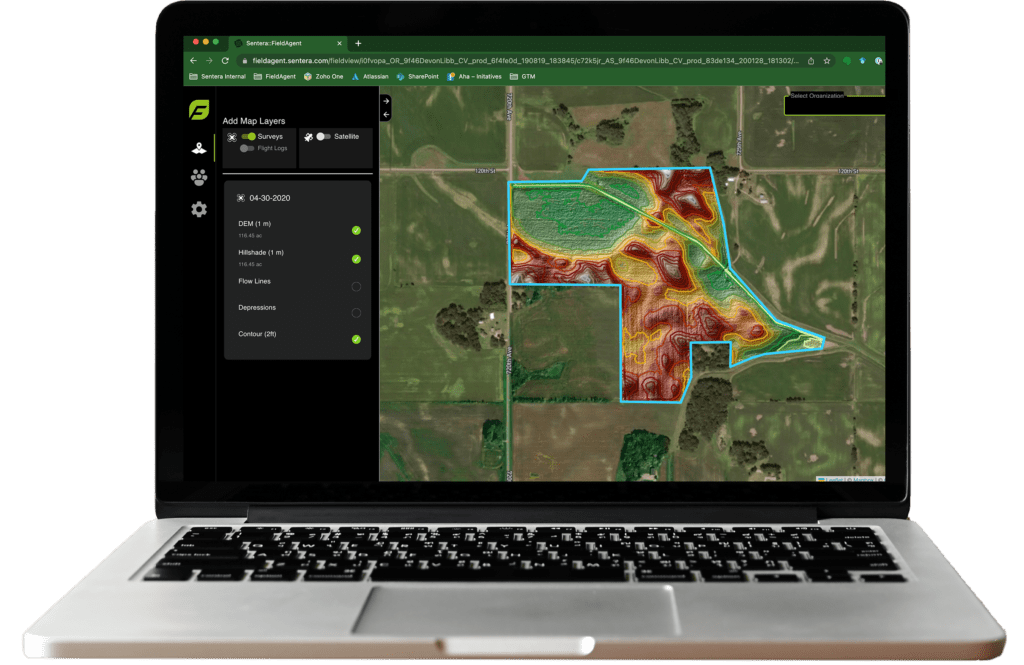
How can you do that? By leveraging the advancements that have been made in technology to assist you in damage control, making critical decisions, and understanding the what and the why behind issues regarding your fields. Field Scale Elevation and Hydrology measurements work to give you insights into how water will interact with your field.
Data sets focused on Elevation and Hydrology work to direct water management strategies by truly understanding the behavior of water. This resource provides intel on how water will flow within your field – from where it will start to where it will end up. Tying directly into the ability to identify areas that are in danger of flooding; giving you the data and time needed to improve or simply avoid the area. Not only does this help improve your crop yield and health, it saves you money and time by investing in areas that are truly sustainable.
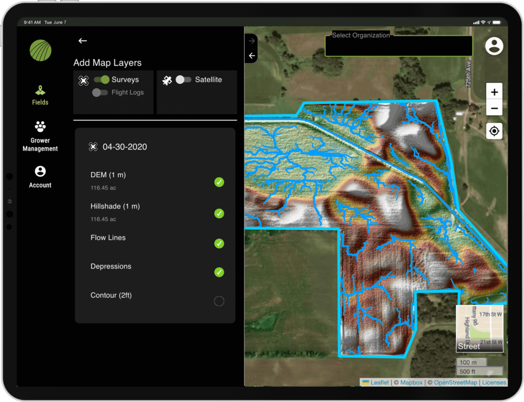
Elevation and Hydrology example highlighting water flow paths and at-risk areas for flooding
Topography: Fields Come in All Shapes and Sizes
Topography is key in determining soil nutrition and crop yield; a field’s variability provides optimal planting places and potential problem areas. When analyzing your field performance, you may have encountered areas in which there were struggles with crop health, growth, yield, or all three. So why are these areas performing differently than the rest?
Determining what areas need improvement early on can give you insight into where to plant, what needs improvement to make it more livable, etc. Not all these areas can be caught by the naked eye, making it extremely important to take advantage of the unique views that technology can provide.
Elevation and Hydrology measurements work to capture views that are otherwise hard to obtain – providing a clearer understanding of the happenings at the field–edge. This technology works to determine areas of the field that are less susceptible to the effects from soil conditions. It is crucial to learn about how the characteristics of soil can play a role in the success of your field.
With varying topography, different areas are going to have different responses to rainfall and irrigation systems. Which is where understanding water flow behavior becomes a key factor in field analysis. Different areas are prone to flooding – as discussed above – and this is especially crucial when gaining knowledge of your field’s geography.
As we hit the end of growing season, consider your goals for the upcoming year and what can help you get there. A full field performance analysis will provide you with the insights needed to make critical decisions and optimize your yields and time. Partnered with these, you have the chance to fix problem areas, ensuring you are not wasting product and money on areas susceptible to less desirable outcomes.
 eBook provides an in-depth look into uncovering the data and insights needed for high performance characterization analytics.