Today, it’s reported that three in four farmers running corporate operations utilize digital agronomy to power critical decision-making. So, what is the story behind this revolutionary technology?
Like all major innovations, it was inspired by searching for a solution to a problem. That problem: issues surrounding soil irregularities. Since then, digital agronomy has since skyrocketed in capabilities and popularity. It’s leveraged for the entire crop health lifecycle, from soil evaluation to turning data collection into a story of on-field performance. Including powering faster decisions about research trials, product performance, and even ongoing crop health management. And now, this technology covers all aspects of evaluation, from data collection to analysis and everything in between.
The decades-long experience has only fueled innovation of digital ag technologies, leading us to where we are today – leveraging ag technology to enhance profitability, sustainability, and yield.
Supporting a Sustainable and Productive Future
When you think digital agronomy, what comes to mind first? Whether it be ag drone systems, machine learning, or supportive software, they all play a pivotal role in the evolution of digital ag.
Among these, the most popular are ag drones and sensors. Drones have existed for over a century, but it hasn’t been since recently that they’ve become popular in agriculture. There are many uses, but the one that has advanced the most has been high-resolution aerial imagery.
This imagery can provide a map of what’s happening across the field – making it easy to understand what’s happening where. The result? More efficient scouting on the ground with a higher focus on accuracy. Producing high-resolution imagery provides precise data and promotes successful ag research with limited to no variability.
Now, these maps – or multispectral indices – captured by drones are translated into detailed data sets, thanks to machine learning models. This has expanded the role of drones and sensors in agriculture. They have become the tools that inform critical business decisions around research, product development, and even long-term product performance. Directly help combat environmental issues surrounding the agriculture industry.
Helping the Bottom Line: Digital Ag and Profitability
Digital ag serves several distinct needs, including building a better grower experience, supporting research trials, and getting new products to market faster.
But, any investment requires a look at how it impacts the bottom line. And there are a few distinct ways that digital ag adoption helps support an organization’s goals to become more profitable.
For one, it results in distinct operational efficiencies by solving processes that may be cumbersome or error-prone. Using technology to capture high-resolution aerial imagery of fields to dig deeper into performance and uncover how to optimize outcomes can help in a few different ways:
- Saving 25% of the time it takes for data collection while resulting in a more comprehensive view of the plots or fields
- Virtually eliminating erroneous data (to less than one percent) because it eliminates the inevitable human error when it comes to counting and measuring plants
- Reducing labor needs by 30%, as the technology takes on more of the manual work
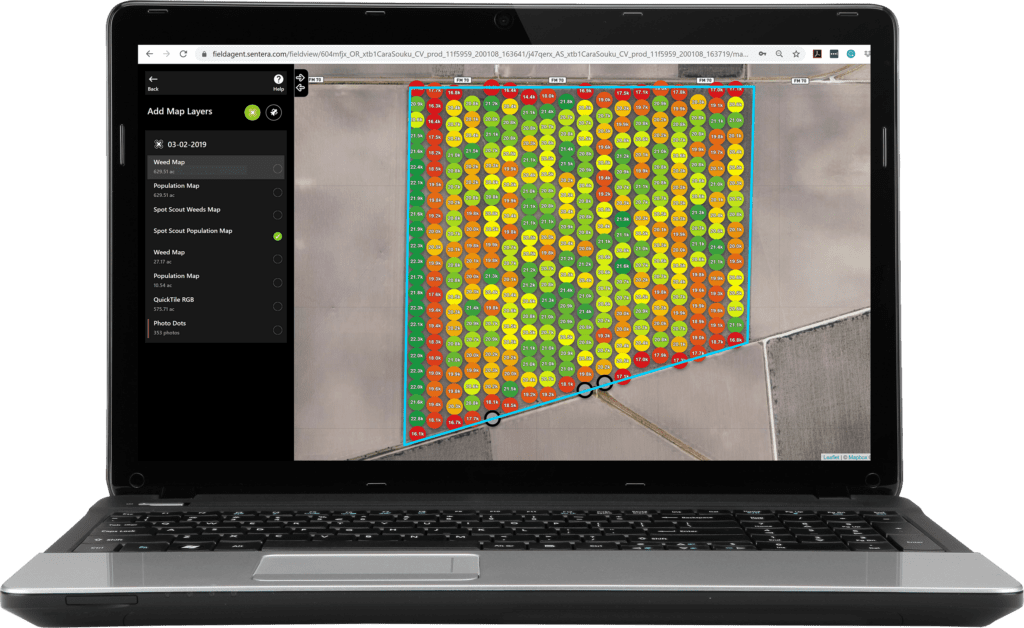
Beyond that, agronomists can use digital ag technology and tools to help tell a story about performance from the early stages. Stand Count data sets count every plant in the field for a clear understanding of what’s happening where.

Laptop View of Stand Count in Sentera’s FieldAgent
This gives visibility into where replanting is needed and areas facing health challenges early in the season – informing key inputs. Beyond that, analytics that details crop health and performance throughout the season can make it easier to monitor crop health all season long. This helps manage inputs and key treatments to apply when and where it’s necessary. While simultaneously providing insight to manage expectations throughout the season.
From driving efficiency to optimizing applications and treatments and providing insights into maximizing performance and yield throughout the season, digital ag technology and tools can help increase efficiency, reduce costs, and, ultimately, positively impact the bottom line.
What Does the Future Hold?
With all the uncertainty surrounding the upcoming years with available labor and resources, supply chain issues, population growth, and climate issues, technologies that fuel digital agronomy, like precision agriculture, are needed more than ever. We will continue to see advancements toward more effective and efficient digital ag products and services.
There will continue to be newer, better technologies as the years progress. Producing overall more effective and efficient results to meet the industry’s high demands and limiting resources. Whether it be longer battery life, faster data capture, or new analysis methods, ag technology industry is continuously evolving.
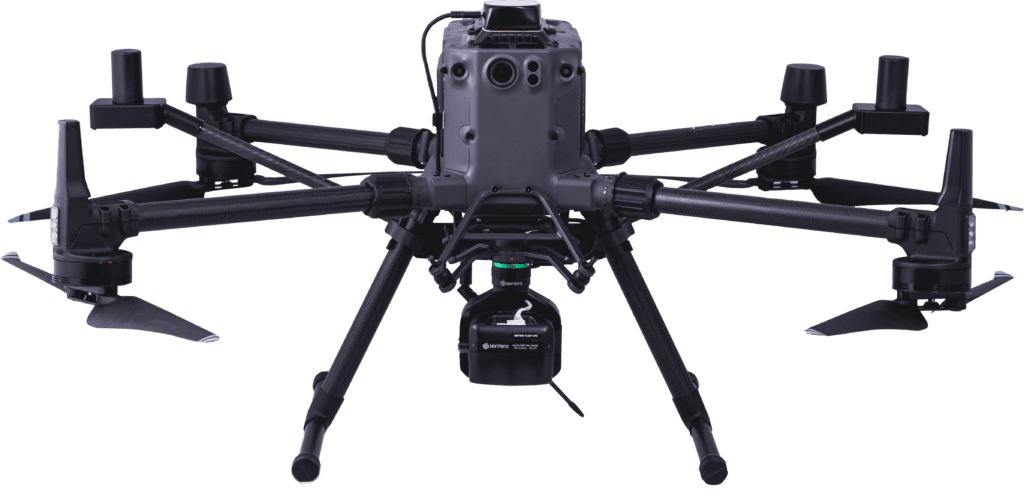
We may be biased, but one of the most disruptive developments in propelling the future of digital ag ahead is Sentera’s Direct Georeferencing (DGR) System. And, like with most innovations, the DGR was created to solve problems facing agronomists.

Sentera’s DGR System mounted on a DJI M300 drone
Using drones in the field solved a big problem by capturing data about every plant. Furthermore, allowing agronomists the ability to understand health, vigor, and maturity. However, creating a map from captured images that are also accurately relative to its location quickly became arduous. Thousands of images needed to be taken, many with overlap, and then “stitched” together to create a unified map. This process can take hours, removing the ability to deliver “real-time” data at the field’s edge.
When using the DGR System, there’s no need for orthomosaic stitching, allowing users to create maps right at the field’s edge. So they can analyze within minutes of capturing the data.
After all, agriculture revolves around timeliness. Choosing the ideal timeframe to plant, harvest, apply inputs, and everything in between can significantly impact outcomes and yield. And, for agricultural data, that’s been one piece that has been challenging.
The idea behind digital ag is to save money, time, and resources while optimizing results – exactly what products like the DGR do. As we look towards the next evolution of digital agronomy, agronomic leaders will continue to rely on new, revolutionary technologies. Such as the DGR that reserves more time to fuel critical agronomic decisions and conduct key, performance-altering analyses.


