The unpredictability of weather has always been one of the biggest challenges growers face with the recent effects of climate change really driving that home. From extreme temperatures and wildfires across North America to drought rampaging the Midwest and record-breaking high temperatures this past summer, there’s no question that growers are facing more weather-related complications now than ever before.
There’s not a whole lot of growers can do to change the weather (aside from adopting sustainable farming practices to reduce their impact on the environment, that is). However, there is no magic app or technology that can protect your fields from or prevent certain weather.
But technology can make a difference when it comes to collecting and tracking weather data. And that data, when combined with crop health analytics, can offer you insights that help you to:
- Understand weather patterns and better inform decision-making and planning
- Accurately estimate your yield
- Create a harvest plan
- Determine whether there are any steps (like treatments, replants, or repairs) you could take to maximize this season’s efforts
What Are Growing Degree Days?
Growing degree days, or heat units, are used to measure and monitor the development of plants and pests – like to estimate the timing of important biological events, such as flowering, fruit ripening, and insect or disease emergence. GDDs are calculated by summing the average daily temperature above a base temperature, which is the minimum temperature at which a particular organism can develop.
Growing degree days can be used to make a variety of predictions about plant and insect development, such as:
- The number of days required for a plant to reach maturity
- The timing of pest emergence and activity
- The risk of frost damage to crops
GDDs are a valuable tool for growers and agronomists alike, but they are not a perfect predictor of plant and insect development. Other factors that can also be monitored with ag technology can assist in providing further insights into plant development.
Unlocking Deeper Insight with Growing Degree Days
Growing degree days are one of these valuable tools into better understanding weather. The crucial role that growing degree days play in the growth cycle – of any crop – is indisputable. But how can growing degree days be used to benefit your agriculture operations?
While flying a drone to collect aerial imagery or pulling analytics using weather and satellite data won’t change the number of growing degree days in your area (or how your crops respond to them), having those data-driven insights at the ready, then being able to compare that information to the current health of the crops in question, is highly valuable for a couple of reasons.
For starters, let’s talk about the importance of specificity. While many growers will still prefer to manually track the day’s high and low temperatures in a notebook for reference, this requires time and effort that growers can better allocate elsewhere. Plus, it’s important to note that completely accurate records are difficult to maintain manually due to simple human error.
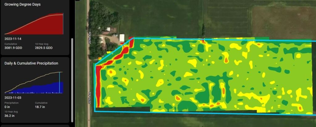
Now, with the help of technology, we can track what each day’s temperature range looked like – down to the decimal point – how long it stayed within a certain range, and whether any other notable weather events (like rain or wind) were present. The image below highlights GDDs; as well as, daily and cumulative precipitation as seen in Sentera’s FieldAgent.
But it doesn’t stop there.
Because modern agriculture data systems can automate the data collection process and compare data points from multiple sources, so you can easily take GDD data and compare it to crop health data, which may be based on Normalized Difference Vegetation Index (NVDI) imagery taken by satellite or drone imagery.
Using AgTech to Answer the Big Questions
Seeing where the crops are on specific data points then comparing that to the growing degree days data and where you are in the season provides you with information you need to answer some nail-biting questions, like:
- Are there areas of your field that are not lining up with what you’d expect for crop health based on the GDD data? Now is the time to determine whether any additional treatments should be considered or if action should be taken. With the aerial imagery data, you can also determine with incredible precision where in the field there are spots in need of attention, saving you time and money in scouting and treatment.
- What should your harvest plan look like? Are there parts of acreage that will be ready for harvest early? How can you devise a plan that makes the best use of your time and resources – and what can you do now to ensure that plan is actionable when the time comes? If you need to enlist additional labor, adjust your sales strategy, or make other changes, knowing ahead of time is always helpful.
- What trends should you take note of? Weather is becoming more extreme on a global scale, but what matters for your crops is knowing, to the best of your ability, what to expect in your fields. Collecting, analyzing, and tracking this weather data from one season to the next gives you the best possible insight into how temperatures and other weather events are changing over the years in your region. And that allows you to adjust your plan to be as prepared as possible. Whether that’s extending pre-plant to avoid a late-spring cold snap, investing in crop insurance for crops that have become riskier, or even looking into alternative crops if you notice strong weather trends that no longer benefit your current crop.
And, another benefit of modern agriculture technology is the fact that systems like Sentera’s FieldAgent can be set up to send you notifications for any noteworthy weather-based events., This enables you to respond in near-real time to potential problems caused by excessive rain, hail, wind, or frost/freeze, as well as unexpected drops in crop health values or conditions that increase the likelihood of disease.
Technology might not solve all your weather-related problems in agriculture, but there’s plenty that satellite and weather data can do to help you get through whatever proverbial storm comes your way.
 , to learn more about monitoring crop health through times of less-than-ideal weather conditions.