Over the past decade, high-resolution multispectral and RGB aerial imagery has proven its value for agriculture.
This data is essential. From providing researchers with insights into phenotyping work to helping seed production experts create side-by-side demonstrations in contract fields. Particularly in improving data quality and increasing the scale that details crop health and performance measurements.
High-resolution aerial imagery starts by flying a drone, speeding up data collection by about 25% – while providing 100% capture. From there, the key workflows become a bit complex and time-consuming.
That’s been a challenge that the team at Sentera has been working to solve. Accelerating the entire process from data collection to analysis, researchers and product developers can get data faster without sacrificing accuracy.
How it Works Today: Generating Orthomosaic Maps for Analysis
Flying a drone over plots and fields captures hundreds of high-resolution images. On average, each ground point mapped before the flight ends up being photographed six or more times. This ensures enough data for stitching – which fuses hundreds of images into a single, geo-located, orthomosaic map.
This process can take hours, greatly impeding the time saved by using drones to capture data in the first place.
Beyond the amount of time it takes to create an orthomosaic map, there are a few other drawbacks:
- It requires network bandwidth to move gigabytes of imagery to and from the field, which isn’t always readily available
- Stitching software can be expensive, adding to the overall costs of data collection and processing
- Redundant images must be taken and stored to build an accurate orthomosaic map; oftentimes, there’s as much as 70% overlap between images
The time wasted in the field – not to mention the excessive data volume – capturing these redundant, repetitive images. And, on top of that, the added hours waiting for an outside program to stitch it together. This wasted time takes away from the time needed to analyze the data, which pushes critical decision-making.
By adding geolocation accuracy to every image that is captured by a drone, it can result in immense savings. But before we get into that, let’s look at the DGR System and how it works.
The Anatomy of the DGR System
In short, Sentera’s Direct Georeferencing (DGR) System targets today’s cumbersome process. The end result? A clear map of the field to understand performance.
Why is this such an extensive process? Why can’t you just adjust a normal picture to a map?
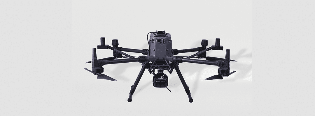
The DGR system itself can be broken down into two key parts that mount to compatible drones: the Dual Antenna RTK and the tactical-grade inertial measurement unit.
Together, these two pieces capture four key aspects that are required for precise and accurate aerial imagery:
- Position, which, typically, will have an average error of a few meters from where the GPS is located
- Orientation, meaning that incorrect angles of the camera can result in significant displacement.
- Range to Scene, which determines how far the drone is from the ground and how the imagery will be scaled
- Time Synchronization, meaning that while there’s an idea of where/when the photograph was taken, lacking exact precision results in error
The Dual Antenna RTK gives a high accuracy position, eliminating the meters’ worth of error seen with other GPS systems. By simply snapping this Dual Antenna RTK to the legs of the drone, you can know exactly where you are positioned – ensuring that the intended position points are covered.
The DGR’s tactical-grade inertial measurement unit (IMU) targets errors from poor camera orientation. Knowing exactly where your camera is angled, you can ensure you’re collecting the imagery that you actually need for analysis.
The long-range single-point LiDAR gives the exact distance that the drone is from the ground, eliminating the error that comes with estimating this. Not only does this provide a more accurate scale, but you can also get insights into the land, such as its topography.
Coming together to create a perfectly orchestrated integration to tell when, where, and how the image was taken. Therefore, providing you with the utmost accurate results.
Combining these four factors simplifies the data collection process by cutting image overlap down by more than 50%.
Though we’re in the agriculture industry, this parking lot image displays the level of accuracy the DGR System captures.
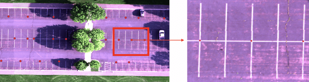
These lines are 4″ wide, and there are little to no noticeable deviations between locations based on ground control points.
And, if we look at more relevant data – this showcases a high-res RGB image for plots. You can barely tell where the seam exists between images:
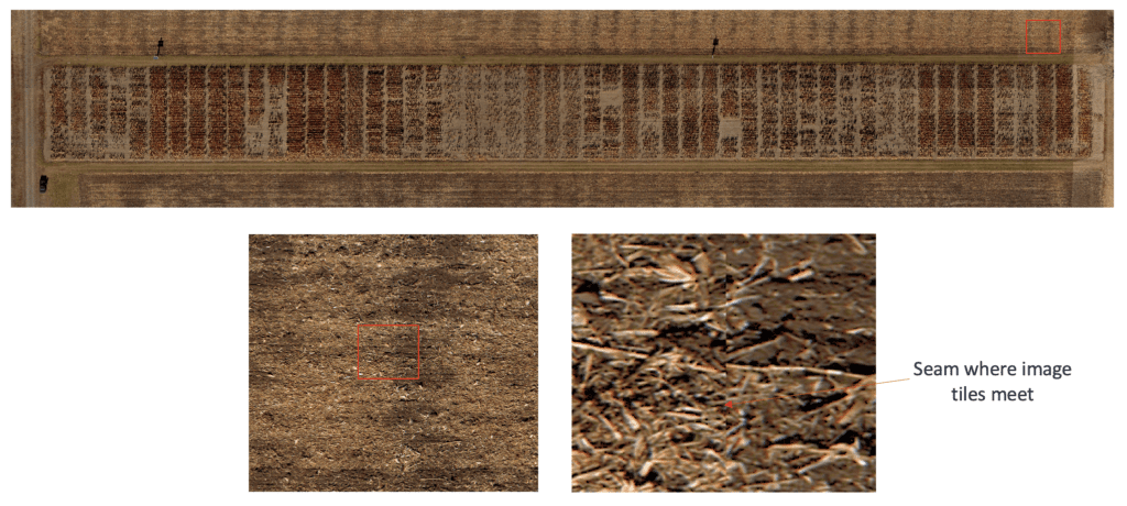
These images are created without stitching or producing an orthomosaic map. With the DGR System, you can go from capturing the data to analyzing it in just a matter of minutes. As a result, you know exactly what’s happening within your plots or fields before even leaving the field’s edge.
The DGR System: One of its Kind
The DGR System goes beyond the means of today’s stitching technologies – completely revolutionizing an otherwise inefficient and cumbersome technology. Because of stitching’s inefficiency, it’s become the “necessary evil” for those using high-resolution aerial imagery to collect data for agronomy. By utilizing the DGR, you completely cut out ever needing to stitch an image again – saving hours of time.
But it’s not just that – it also saves time elsewhere in the process. For instance, because you capture up to 9x fewer images while in flight, you can reduce flight times by 60%.
With more traditional methods wasting time on oversampling fields and high processing overhead, there was a need for a new technology to combat the inefficiencies surrounding stitching orthomosaic maps.
Nothing of this magnitude has been brought onto the market – making the DGR a one-of-a-kind innovation. With virtually nothing coming close to its capabilities – the speed and accuracy provided by the DGR are unprecedented. Thus, completely disrupting today’s industry and the process of translating high-resolution aerial imagery into detailed data sets and measurements.
And, just like the DGR System – we’re just getting started! Stay tuned for our December 2nd blog post covering the power and the key use cases of Sentera’s DGR System.
 , for a deep dive with Sentera's Ryan Nelson, chief mechanical engineer.