There’s no denying the incredible value of precise measurements in plot trials, whether they’re being conducted for product development or for research purposes. After all, in an industry where even the smallest differences have the potential to bring us closer to the perfect product or the solution to an industry-wide challenge, understanding as much as we can about our samples isn’t just helpful – it’s imperative.
The question is, are you getting everything you can out of your measurements? And even if you’re collecting the specific data on measurements you need today, are you sure you’ve recorded every measurement that might become important to your plot trial in the coming years?
For instance, maybe you’re mainly focusing on stand count and uniformity. That’s fair – those are key measurements! However, if you have a sample that begins showing surprising signs of weed tolerance, for example, but you have not been tracking that measurement (and any related analytics) since the beginning of your plot trial, how much critical data might you have missed?
The thing is, the data available today, at this moment, cannot be replicated or retrieved if you don’t collect it now. Can you afford not to make the most of every measurement opportunity, especially knowing the seasonality of agriculture?
The Unmistakable Impact of Aerial Imagery
Gathering additional measurements has, historically, required additional time, effort, and expertise. Makes sense, right? You need someone walking the field, recording all the relevant data – and that person needs to be someone who understands what they’re looking at and how to record it with accuracy and objectivity. At times like these, when labor is already difficult to source, finding the right person to take your data collection to the next level using manual methods can be a real hurdle.
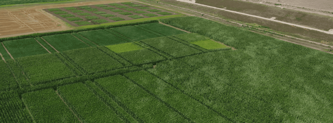
And that’s one reason why using drones and sensors to collect aerial imagery makes such a huge difference in plot trials. You can collect more measurements, with greater precision, in a fraction of the time – and without requiring someone with expert knowledge and years of experience to walk your field.
With the right training, many people can fly a drone (or, of course, that can always be hired out to a flight service). The drone handles the collection of every data point, and the software it pairs with keeps that data organized so that you can grab what you need, when you need it. And, because it’s all saved in an image, that data is there for your current and future needs – because you don’t necessarily know today what data you’ll need for tomorrow.
Changing With the Times
It’s not only advances in technology that influence which measurements we’re analyzing, but the world in which we live. Consider the concerns we’re addressing today, like climate change, the lack of nitrogen in the soil, plus the one-two punch of a demand for more productivity paired with increasingly limited farmland.
When the Wisconsin Agronomy Department, the Wisconsin Crop Improvement Association, and the seed industry began conducting their corn-hybrid performance evaluation back in 1973 (and yes, that’s half a century ago), there were plenty of performance indicators that were on their radar – and continue to be today. But what might they have done differently if they’d known how big an issue limited farmland or climate change would be today? And what data might we want to record now to ensure we’re prepared for any new challenges that arise in the future?
This is another area where this aerial imagery makes such a key difference in plot trial measurements. Not only does it provide full-field, precision coverage, but those images are the data. Whether you pull and analyze a measurement today, tomorrow, or in 10 years, it’s there, embedded in the image, and will remain there as a snapshot in time of your plot trial whenever you need it.
What’s more is that this data becomes even more valuable as machine learning becomes more prominent in agriculture. Ag modeling solutions can leverage historical data points for a retrospective analysis, which also trains and tunes a model that can be used for real-time predictions or forecasts as new data becomes available.
When More Is Actually More
Even better? Technology helps to store, organize, and visualize the data – with options to pull it into your own tools for deeper analysis.
In the past, when relying on manual methods, taking more measurements didn’t only require more effort to record, but doing so also required more effort when it came time to put it into your system, let alone make use of it. With aerial imagery captured by drones, however, getting more doesn’t require doing more; it just requires the right tools and software. Once you have that, the process becomes incredibly simple.
So much so, in fact, that you might just find yourself looking into an expansion of your current trials. After all, if you can collect, store, and analyze additional fields with the same (or less) effort as your current plot trials requires, doesn’t it make sense to keep adding more?
