
Whatever your particular role within the agriculture industry, one thing is certain: precision ag technology, like aerial imagery, has the power to take your business to new heights.
How you ask? For one thing, this method captures data 25 percent faster than manual methods – and delivers that data 50 percent faster. And, regarding accuracy, drones and satellites capture aerial imagery with 100 percent coverage and a less than 1% error rate. Why wouldn’t you want to collect more accurate data in less time, right?
That being said, it’s important to note that not every form of aerial imagery or data collection method is right for every stage of the growing season. The data you’re hoping to collect and standardize and when you’re hoping to gather will determine what you should use to collect and analyze that information.
Suppose you aren’t already collecting data via aerial imagery but are interested in doing so. In that case, you’ll first want to familiarize yourself with the drone systems and sensors available to determine which options best fit your needs. You can learn more about drones and sensors in depth here.
Ag Drone & Sensors Breakdown
Sensor capability: Different drone systems can collect different drone data. The most common is the visual color RGB (red, green, blue). These images appear how you’d view them with your naked eye, and most commercial drones are equipped with these cameras.
Multispectral: These allow you to learn more about plant health by showing what you cannot see with the naked eye. Including insights into crop conditions based on how vegetation reflects light in near-infrared spectrums.
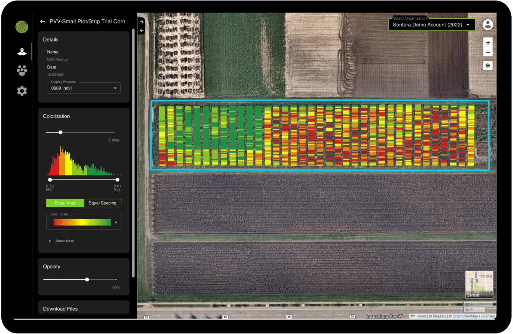
Example of a multispectral image (NDVI) captured via a drone of a plot trial
And, if you’re looking for the most repeatable, highest precision analysis available, you may need calibrated multispectral, which is most commonly used in seed performance and academic research.
Coverage: An entry-level multi-rotor drone is effective for a smaller or harder to maneuver operation. But, if you have more acres, a larger multi-rotor or even fixed-wing drone is preferred since these have greater endurance and coverage. A longer battery life and higher endurance allow you to collect more data over a larger area with less effort.
Footprint and Operation: Although larger drones might be appealing for their coverage capabilities, it becomes tricky to store or transport with limited room. And, when it comes to operating drones, it’s important to know the ins and outs of larger, fixed-wing drones. Although they offer great coverage, they also require more planning and skill to operate than multi-rotor platforms.
Now, hopefully, you have a general understanding of what to look for in a drone system and just how big of a difference this aerial imagery can make. Regarding the accuracy of your data, it might be helpful to see how these agriculture solutions might benefit your specific industry.
Research and Development
Collecting data from your plot trial for product development isn’t only faster and easier when you use the aerial imagery. It also provides greater objectivity and accuracy with measurements and analytics, making it possible to scale your data collection methods. Once data collection is complete, standardizing and visualizing that data with real-time performance monitoring is a snap.
For research and development – precision and accuracy trump all. Knowing this, using a multi-imager or a sensor with multiple lenses to capture detailed imagery can be the best option. In addition to providing science-grade measurements, these sensors also have options for radiometric calibration to remove any variability. This means you can trust that the data will give you precise and true insight into plot trial performance.
Seed Production
Looking for ways to improve your seed production? Aerial imagery has your back once again. This technology allows you to validate detasseling and product purity, forecast your yield, and monitor real-time performance. Making it possible for you to make important decisions promptly gives you the best chance to meet your goals.
Machine learning is also an important component of high-throughput phenotyping for seed breeding. The use of aerial imagery plays a key role in increasing the frequency and accuracy of measurements and speeding up the time for analysis.
Much like research and development, having an ag drone system designed to capture precise detail with unprecedented accuracy comes first. Especially when you look at digitally verifying detasseling operations, it’s important that you can track data down to the tassel to understand what is happening within the field.
For this, having a drone that has the endurance to cover acres faster, paired with a sensor that offers versatility for drone collection, will be important. We may be biased, but we love our PHX Fixed-Wing Drone paired with the Double 4K Analytics Sensor.
Crop Production
In the crop production segment, the benefits of aerial imagery can’t be overstated. For seed dealers and agronomic advisors, drones and satellites capture data that can show what’s working and what’s not. This allows you to provide suggestions for how growers can maximize their yield at each growing stage. Another invaluable perk is building strong relationships and providing a customer experience that’ll pivot from the competition.
For the growers themselves, aerial imagery is the most precise and efficient way for them to gather data. Year after year, it allows better identification trends for unexpected changes in their fields or crops. This allows them to make adjustments in the field to improve performance and dial in their market strategy. And that’s not all – the data collected from aerial imagery also helps to build comprehensive portfolios to assist in negotiating loans, leases, insurance, and more.
For crop production, the options for drone and sensor combinations can be overwhelming. But it all comes down to the data you want to collect and how you will use it.
Those seeking an entry point to see what aerial imagery is all about would do well. Entry-level drones and sensors focus on capturing crop health maps – like NDVI and NDRE.
Once you dip your toe into the water, the data becomes addicting. That opens the universe of ag drones to far more options. As intended, they are designed to get more detailed analytics, from early emergence data to end-of-season outcomes and yield forecasting.
Of course, as is the case with any data, regardless of how you collect it, being clear on what you need to know from the get-go is the key to efficiency. Collecting more data without a plan for how to use it is never an efficient use of resources, so plan and choose wisely.
 gives you the insight you need to determine the best solution. Download it now.